CPEC Logistics Capacity: Karakoram Highway vs. the Proposed Trans-Karakoram Rail Link
By Marivel Guzman | Akashma News
A Supplementary Technical Analysis to “The Strategic Nexus of the New Silk Road”
Prepared: September 11, 2026
1. Scope Note
The source document supplied for this analysis (Guzman, 2026) addresses CPEC’s geopolitical framing, Gawadar’s naval/commercial role, and Pakistan’s debt exposure to Chinese IPPs — it does not contain freight-throughput, TEU, or rail-engineering data. The figures below are drawn from separate research (government statements, NHA/Pakistan Railways disclosures, and peer-reviewed capacity modeling) to answer the logistics-specific questions posed. Where projections are estimates rather than confirmed government figures, this is flagged explicitly.
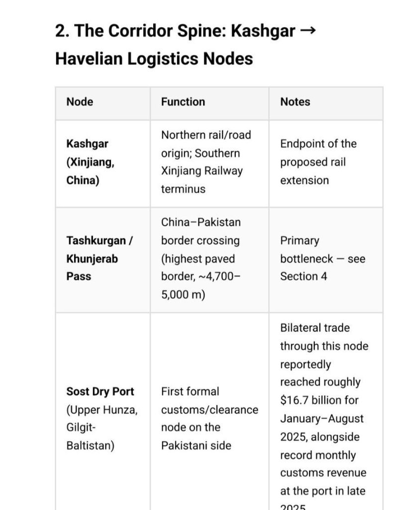
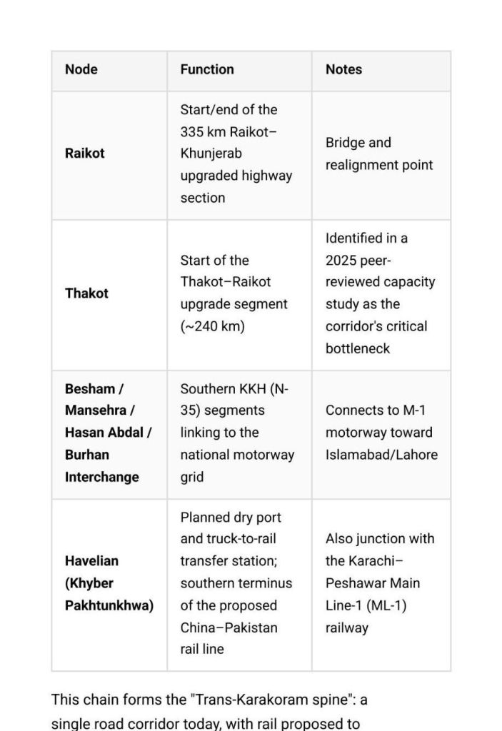
3. Highway Capacity: The 10 m → 30 m Widening Program
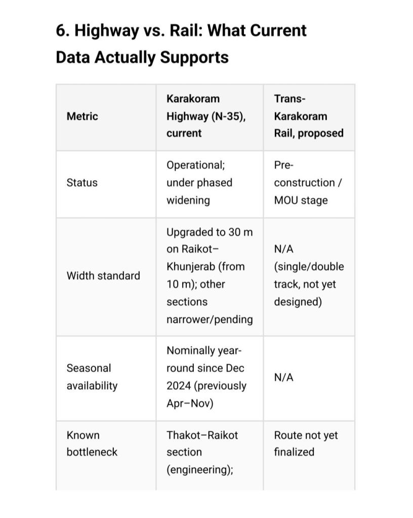
The Raikot–Khunjerab Section (335 km) was upgraded under a **$327.74 million China Eximbank loan** (total project cost ~$491–500 million), completed in November 2013. This project widened the roadway from 10 meters to 30 meters, added 32 new bridges (27 rehabilitated), and was designed to keep the route passable year-round and suitable for heavy, long-body freight vehicles.
Further upgrades are ongoing or planned:
Thakot–Raikot section (~240 km): MOU-stage realignment and upgrade, discussed during 2023 high-level visits, cost estimated in the billions of rupees.
Hasan Abdal–Mansehra section: NHA is reviewing dualization/rehabilitation of the existing carriageway to relieve congestion and slow-moving freight trailers.
Attabad Lake realignment section: Chinese-financed realignment, expected multi-year timeline.
Net effect: the KKH’s Pakistani alignment (N-35, 887 km) is being converted piecemeal from a narrow, seasonally vulnerable mountain road into a wider, hardened freight corridor — but full end-to-end dualization is not yet complete.
4. Bottleneck Analysis: Khunjerab Pass and the Thakot–Raikot Chokepoint
Altitude and seasonal closure (historical bottleneck):
– Khunjerab Pass sits at roughly 4,700–5,000 m, the highest paved international border crossing in the world.
– Under the 1985/2013 border protocols, the pass was traditionally open only April–November, closing December–March due to snow and low-oxygen conditions — a structural constraint on annual freight capacity.
– Following an October 2023 announcement at the Belt and Road Forum, China and Pakistan agreed to convert Khunjerab to **year-round operation; this took effect starting December 1, 2024. However, implementation has been uneven — the pass has also seen ad hoc closures tied to trader disputes over customs procedures (e.g., a multi-month suspension in 2025 over new scanning fees at Sost, resolved that October).
– Practical effect: even after the year-round policy, the corridor remains vulnerable to (a) residual heavy snowfall requiring active clearance, and (b) customs/administrative friction at Sost.
Engineering bottleneck (current capacity constraint):
A 2025 peer-reviewed capacity study (Adeel et al., *Scientific Journal of Silesian University of Technology – Transport*, 2025) modeling the Burhan–Khunjerab route specifically for a 2035 horizon found:
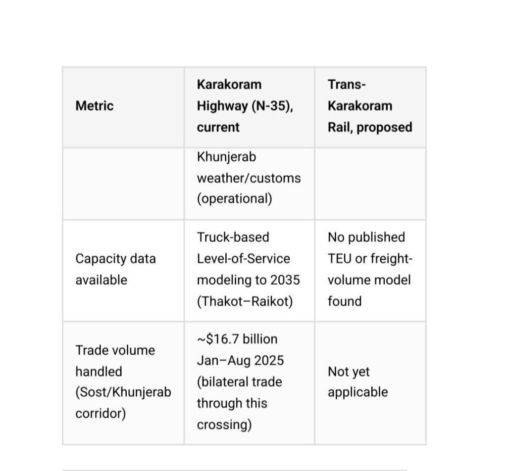
– The Thakot–Raikot section — not Khunjerab itself — is the critical bottleneck, with a modeled additional capacity of roughly 9,519 trucks/day at Level of Service “C” before saturation.
– Under trade-growth assumptions, the corridor is projected to carry about 7.93% of China’s total trade value** and 6.39% of trade tonnage by 2035 if current capacity-expansion plans proceed.
– Statistical relationships derived: each $1 million annual increase in Pakistan’s trade correlates with ~1.3 million ton-km of additional road freight; each 1-million-ton increase in trade volume adds ~1,684 million ton-km of freight movement.
Takeaway: Khunjerab’s altitude/weather profile is the *headline* bottleneck in public narratives, but the *binding engineering constraint* identified in recent modeling sits further south, at Thakot–Raikot — the still-unupgraded middle section of the highway.
No freight currently moves by rail across the Khunjerab/Kashgar frontier — this is a proposed, not operational, corridor.
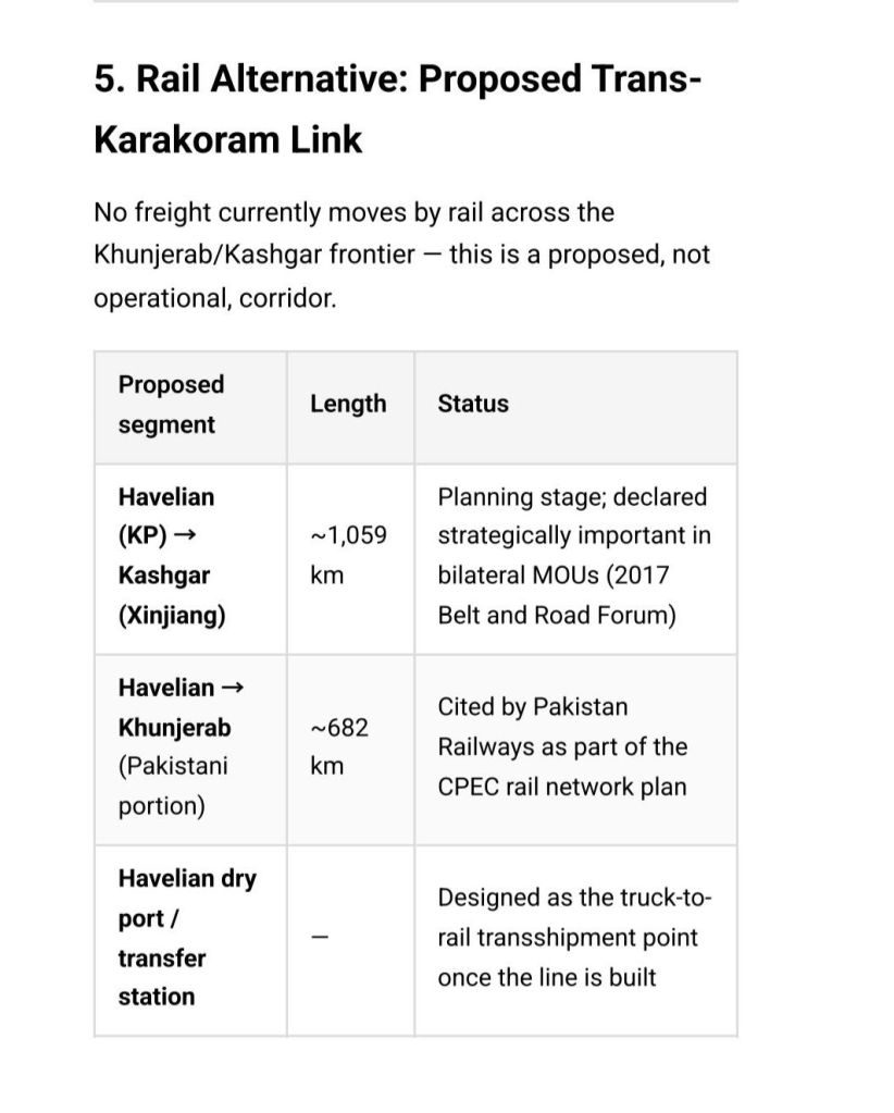
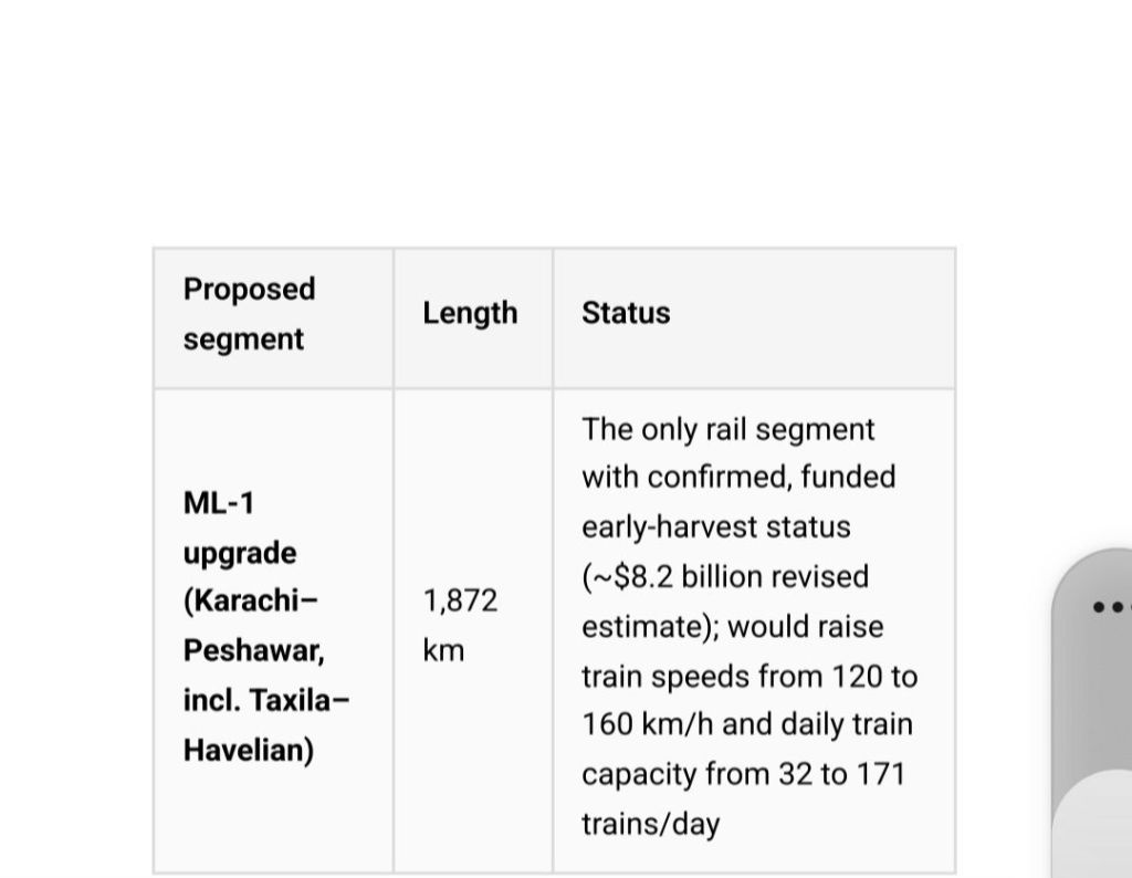
On TEU capacity: No official, engineering-grade TEU throughout projection specifically for the Kashgar–Havelian rail line has been published in government or peer-reviewed sources found in this research. Public statements to date describe the line only in route-length and strategic terms, not container-volume terms — the project remains pre-feasibility/MOU stage rather than at the design stage where TEU modeling would normally be produced. Any TEU figure attributed to this rail link in third-party commentary should be treated as speculative rather than an official target; I’d flag any such number to you rather than present it as sourced. If you need a comparative estimate, an alternative is to benchmark against ML-1’s confirmed capacity uplift (32→171 trains/day) and the trade-tonnage growth rates in Section 4 as a proxy for potential rail demand — I can build that model if useful.
7. Government Targets Toward 2030
– CPEC’s overarching route — 3,218 km of roads, railways, fiber-optic lines and pipelines linking Gwadar to Kashgar** — carries an official completion horizon of **2030**, per Pakistani government statements dating to the corridor’s 2015 launch.
– China’s cumulative investment/contribution under CPEC has been projected by Pakistan’s Planning Commission Centre of Excellence to exceed $100 billion by 2030** (up from an initial $46 billion, revised to $62 billion as of 2018 estimates).
– No single, current, official document was found in this research that sets a specific **TEU or tonnage target for 2030** on the Karakoram Highway or the rail corridor specifically; targets that do exist are expressed in dollar-value trade terms and megawatt/kilometer infrastructure terms rather than container throughput.
8. Caveats
– Figures on cost, length, and dates come from a mix of government statements, wire reporting, and one peer-reviewed engineering study; some (e.g., project costs, MOU-stage segment lengths) have shifted between sources over the corridor’s 15-year history and should be treated as approximate.
– The absence of a published TEU projection for the rail link is itself a finding — it indicates the project has not reached the design stage where such projections are normally produced, not that the figure exists but was simply unavailable to this search.
The Strategic Nexus of the New Silk Road
CPEC Logistics Capacity: Karakoram Highway vs. the Proposed Trans-Karakoram Rail Link
Under Siege: The Security Crisis Threatening CPEC and Gwadar Port
Balochistan the poorest province of Pakistan
The “All-Chinese” Swap: Fact-Checking the Labor Myths in Overseas Lithium Mining
-
September 13, 2026 at 12:18 amThe Strategic Nexus of the New Silk Road | Akashma Online News


